ATC Operations | IVAO Algeria
Welcome to IVAO and specifically, to the Algeria division. Yes, that really is the full name! Controlling on IVAO isn't like other networks, you really can just jump right in without any training or approval from anyone. However that's a really bad idea. This guide will assume that you've already registered an account on IVAO, but if you haven't then go here and follow the steps, choosing Algeria DZ as your division.
- Flight Level restrictions
- ATC Operations department
- DAAA Algiers FIR Sectorisation
- Speed Restrictions
- Radio Failure Procedures
- Airspace classifications
- Notam - Metar - Taf DAAA-FIR Algeria VFR/IFR
- Algerian Airspace - IFR Charts
Flight Level restrictions
Flight Level restrictions
- VFR flights shall not be operated FL145 and above, nor at trans-sonic or supersonic speeds.
- The airspace above FL650 is unclassified, uncontrolled airspace where only IFR flights are allowed.
- DZ division airspace conforms to RVSM.
ATC Operations department
Welcome to the ATC Operations (AO) department. Here you will discover who we are and what are our tasks within the Algeria division.
The Algeria ATC Operations (AO) department is responsible of all activities related to air traffic control within the territories under the responsibility of the IVAO Algeria division. These territories include the DAAA FIR Algeria and the overseas departments.
In particular, we are in charge of:
- managing and keeping updated the list of Algeria ATC units and their associated frequencies
- managing the FRAs (Facility Rating Assignment) of Algeria ATC units
- realising, validating and keeping updated the ATC tools needed on IVAO (Aurora sector files). It should be noted that we are not responsible of the sector files used within IvAc2 since they are developed by teams external to IVAO
- realising, validating and keeping updated the ATC documents (, notes, schemes,...)
- coordinating the realisation and ensuring the application of the LOAs (Letters of Agreement) internal to our FIR and between neighbouring FIRs, both managed by Algeria division and by foreign divisions
- validating the ATC planning realised for the events organised by the division
- developing and realising activities specifically devoted to ATC.
Given our responsibilities, we work in close collaboration with the FIR teams and with the Events department.
To contact us, please use the following email address : dz-atcops@ivao.aero
DAAA Algiers FIR Sectorisation
DAAA Algiers FIR Sectorisation
Cliquez ICI pour voir le diagramme de notre sectorisation
FIR d'Alger - Fréquences
| Ville |
ICAO
|
APP
|
TWR
|
GND
|
|---|---|---|---|---|
| Alger |
DAAG
|
121.400
|
118.700
|
121.800
|
| Oran |
DAOO
|
128.200
|
118.100
|
-
|
| Jijel |
DAAV
|
-
|
119.700
|
-
|
| Bejaia |
DAAE
|
-
|
118.900
|
-
|
| Tlemcen |
DAON
|
-
|
119.700
|
-
|
| Tiaret |
DAOB
|
-
|
118.100
|
-
|
| Constantine |
DABC
|
120.100
|
118.300
|
-
|
| Chlef |
DAOI
|
-
|
119.000 |
-
|
| Hassi Rmel |
DAFH
|
-
|
119.700
|
-
|
| Setif |
DAAS
|
-
|
119.700
|
-
|
| Hassi Messaoud |
DAUH
|
120.000
|
118.100
|
-
|
| Annaba |
DABB
|
119.000
|
118.700
|
-
|
| Tebessa |
DABS
|
-
|
118.100
|
-
|
| Illizi |
DAAP
|
-
|
118.700
|
-
|
| Batna |
DABT
|
-
|
118.100
|
-
|
| Biskra |
DAUB
|
-
|
119.700
|
-
|
| Touggourt |
DAUK
|
-
|
119.700
|
-
|
| Bechar |
DAOR
|
-
|
118.700
|
-
|
| Ouargla |
DAUU
|
-
|
118.700
|
-
|
| El Oued |
DAUO
|
-
|
119.700
|
-
|
| In Salah |
DAUI
|
-
|
118.100
|
-
|
| Bou Saada |
DAAD
|
-
|
118.100
|
-
|
| Bordj Mokhtar |
DATM
|
-
|
119.700
|
-
|
| In Amenas |
DAUZ
|
-
|
119.700
|
-
|
| Djanet |
DAAJ
|
-
|
118.100
|
-
|
| Tindouf |
DAOF
|
-
|
119.700
|
-
|
| El Golea |
DAUE
|
-
|
119.700
|
-
|
| Ghardaia |
DAUG
|
-
|
118.900
|
-
|
| Tamanrasset |
DAAT
|
-
|
118.100
|
-
|
Speed Restrictions
All speeds indicated on approach charts are maximum speeds, thus xxxkts IAS or less. All speeds must be complied to, unless otherwise instructed by ATC in controlled airspace.
| Controlled and uncontrolled airspace | 250kts IAS below 10000ft |
| Inside an ATZ or CTR | 160kts IAS for reciprocating-engine aircraft |
| 200kts IAS for turbine-powered aircraft | |
| Below any TMA | 180kts IAS |
| STAR | Comply with published STAR speeds ( Not applicable ) Only DAUH |
| Non-STAR speeds | 250kts IAS below 10000ft |
| 180kts IAS 10nm on the localiser or from touchdown | |
| 160kts IAS until OM or 4nm from touchdown | |
| On SID | 250kts IAS below 10000ft |
For airfields at higher altitudes see table below for specific airports/airspaces:
| DAAG TMA | 250kts IAS below FL150 ( During event HQ or DV ) |
Radio Failure Procedures
VMC
- Squawk 7600
- Continue VMC
- Land at nearest suitable aerodrome
IMC
Comply as per published charts for applicable aerodrome/procedure.
- Arrival
- Enter the most applicable hold according to your filed FPL route,
- Begin descend as close as possible to ETA + 10 minutes,
- Complete full instrument letdown and arrive within 30min of the above time.
- Departure
- Decide to return to departure field or continue as per FPL,
- If returning see IMC Arrival,
- If continuing, turn onto FPL route and climb to last assigned level. Maintain for 3 minutes, climb to FPL Flight Level.
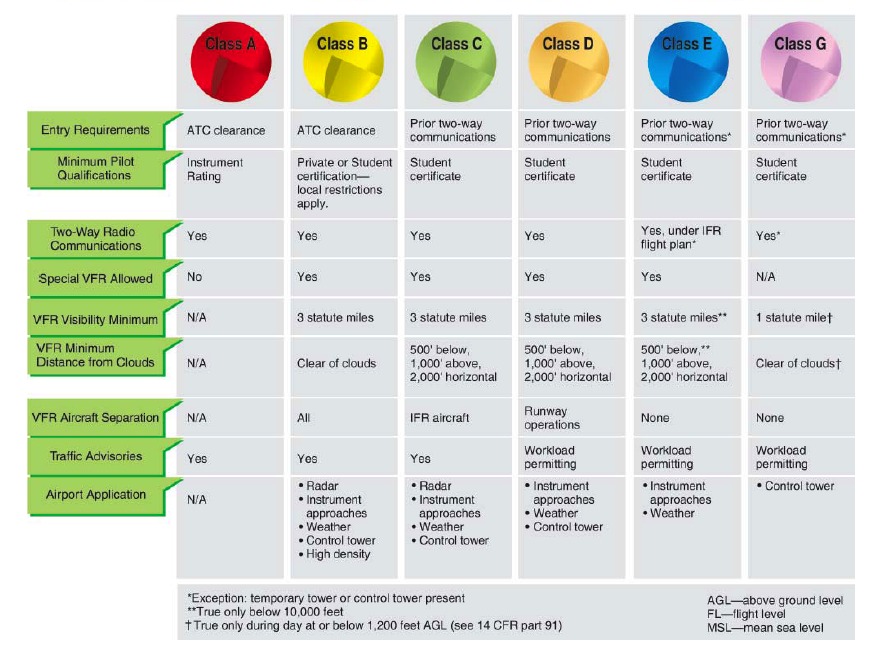
Airspace classifications
For more information about airspace classifications, please refer to ENNA . AMDT/AIRAC/AMDTAIRAC03.
Airspace in the United States is designated through the following airspace classifications:
| Class | Description |
|---|---|
| Class A | Generally, airspace from 18,000 feet mean sea level (MSL) up to and including fl ight level (FL) 600, including the airspace overlying the waters within 12 nautical miles (NM) of the coast of the 48 contiguous states and Alaska. Unless otherwise authorized, all pilots must operate their aircraft under instrument flight rules (IFR). |
| Class B | Generally, airspace from the surface to 10,000feet MSL surrounding the nation’s busiest airports in terms of airport operations or passenger enplanements. The configuration of each Class B airspace area is individually tailored, consists of a surface area and two or more layers (some Class B airspace areas resemble upside-down wedding cakes), and is designed to contain all published instrument procedures once an aircraft enters the airspace. An air traffic control (ATC) clearance is required for all aircraft to operate in the area, and all aircraft that are so cleared receive separation services within the airspace. |
| Class C | Generally, airspace from the surface to 4,000 feet above the airport elevation (charted in MSL) surrounding those airports that have an operational control tower, are serviced by a radar approach control, and have a certain number of IFR operations or passenger enplanements. Although the configuration of each Class C area is individually tailored, the airspace usually consists of a surface area with a 5 NM radius, an outer circle with a 10 NM radius that extends from 1,200 feet to 4,000 feet above the airport elevation and an outer area. Each aircraft must establish two-way radio communications with the ATC facility providing air traffic services prior to entering the airspace and thereafter maintain those communications while within the airspace. |
| Class D | Generally, that airspace from the surface to 2,500 feet above the airport elevation (charted in MSL) surrounding those airports that have an operational control tower. The configuration of each Class D airspace area is individually tailored and when instrument procedures are published, the airspace will normally be designed to contain the procedures. Arrival extensions for instrument approach procedures (IAPs) may be Class D or Class E airspace. Unless otherwise authorized, each aircraft must establish two-way radio communications with the ATC facility providing air traffi c services prior to entering the airspace and thereafter maintain those communications while in the airspace. |
| Class E | Generally, if the airspace is not Class A, B, C, or D, and is controlled airspace, then it is Class E airspace. Class E airspace extends upward from either the surface or a designated altitude to the overlying or adjacent controlled airspace. When designated as a surface area, the airspace will be configured to contain all instrument procedures. Also in this class are federal airways, airspace beginning at either 700 or 1,200 feet above ground level (AGL) used to transition to and from the terminal or en route environment, and en route domestic and offshore airspace areas designated below 18,000 feet MSL. Unless designated at a lower altitude, Class E airspace begins at 14,500 MSL over the United States, including that airspace overlying the waters within 12 NM of the coast of the 48 contiguous states and Alaska, up to but not including 18,000 feet MSL, and the airspace above FL 600. |
| Class G | Airspace not designated as Class A, B, C, D, or E. Class G airspace is essentially uncontrolled by ATC except when associated with a temporary control tower. |
Notam - Metar - Taf DAAA-FIR Algeria VFR/IFR
NOTAM and METAR & TAF Décodeur visuel
Algerian Airspace - IFR Charts
| ALGIERS AIRPORT - DAAG | Files |
| Carte DAAG Update 16/12/2022 |
 DAAG 12 2022 Jeppesen (1.2 Mo) DAAG 12 2022 Jeppesen (1.2 Mo) |
| Carte DAAG ILS RWY 27 |
DAAG New ILS OR LOC RWY 27 (61.36 Ko) |
| Carte DAAG New information Update 2019 | DAAG New information Update (1.26 Mo) |
| Carte DAAG ALG ZEM VOR | Carte DAAG ALG ZEM VOR (111.42 Ko) |
| Carte DAAG CHA LABRO SADEF | DAAG CHA LABRO SADEF (110.99 Ko) |
| Carte DAAG SID BOURI MOGIL OTARO PECES | DAAG SID BOURI MOGIL OTARO PECES (106.85 Ko) |
| Carte DAAG SID BSA | DAAG SID BSA (91.6 Ko) |
| Carte de croisière de la FIR d'Alger AMDTAIRAC03-19 | Carte de Croisiere AMDTAIRAC03-19 (3.59 Mo) |
| Chart ILS or LOC RWY 27 DAAG | Chart ILS or LOC RWY 27 DAAG (93.27 Ko) |
| Carte DAAG AIRPORT Chart | DAAG Airport New Chart 2017 (1.94 Mo) |
| ALGIERS AREA |
|
| DAAG AIRPORT |
|
| DAAG APT INFO TO MINI |
|
| DAAG CAT2 ILS 23 |
|
| DAAG DEPARTURES 1 |
|
| DAAG DEPARTURES 2 |
|
| DAAG DEPARTURES 3 |
|
| DAAG DEPARTURES4 |
|
| DAAG GROUND |
|
| DAAG NDB VOR DME ILS 09 |
|
| DAAG VOR DME 05 |
|
| DAAG VOR DME 23 |
|
| DAAG VOR DME 27 |
|
| DAAG VOR DME ILS 23 |
|
| DAAG VOR DME NDB ILS 09 |
|
|
ORAN AIRPORT - DAOO |
Files |
| DAOO update 16/12/2022 |
DAOO 12 2022 jeppesen (633.67 Ko) |
| ORAN AIRPORT |
|
| DAOO ARRIVALS |
|
| DAOO DEPARTURES 1 |
|
| DAOO DEPARTURES 3 |
|
| DAOO VOR DME 25 |
|
| DAOO VOR DME ILS 25 |
|
| BEJAIA AIRPORT - DAAE | Files |
| BEJAIA AIRPORT |
|
| DAAE NDB LOC DME Rwy 26 |
|
| DAAE NDB LOC DME 26 |
|
| DAAE RNAV (GNSS) Z RWY 08 | DAAE RNAV GNSS Z RWY 08 (103.29 Ko) |
| DAAE RNAV (GNSS) Z RWY 26 | DAAE RNAV GNSS Z RWY 26 (71.67 Ko) |
| DAAE VOR RWY 26 | Vor rwy 26 (69.8 Ko) |
| CONSTANTINE AIRPORT - DABC | Files |
| DABC Update 16/12/2022 |
DABC 12 2022 jeppesen (418.18 Ko) |
| DABC AIRPORT |
|
| DABC NDB VOR 32 |
|
| DABC NDB VOR DME 34 |
|
| DABC VOR DME 34 |
|
| DABC VOR DME ILS 34 |
|
| DABC VOR ILS 32 |
|
|
HASSI MESSAOUD AIRPORT - DAUH |
Files |
| DAUH AIRPORT |
|
| DAUH ARRIVALS |
|
| DAUH DEPARTURES 1 |
|
| DAUH DEPARTURES 2 |
|
| DAUH VORDME 18 |
|
| DAUH VOR DME 36 |
|
| DAUH VOR DME ILS 36 |
|
| ANNABA AIRPORT - DABB | Files |
| DABB Update 16/12/2022 |
DABB 12 2022 jeppesen (260.49 Ko) |
| ANNABA AIRPORT |
|
| VOR ILS DME Rwy 19 |
|
| LCTR Rwy 19 |
|
| VOR Rwy 19 |
|
| VOR LCTR Rwy 23 |
|
| ARRIVAL & DEPARTURES |
|
| ADRAR AIRPORT - DAUA | Files |
| ADRAR AIRPORT |
|
| DAUA NDB 04 |
|
| DAUA VOR 04 |
|
| ILLIZI AIRPORT - DAAP | Files |
| DAAP AIRPORT |
|
| VOR Rwy 27 New |
|
| BATNA AIRPORT - DABT | Files |
| DAAP AIRPORT |
|
| DAAP VOR 27 |
|
| TOUGGOURT AIRPORT - DAUK | Files |
| DAUK AIRPORT |
|
| DAUK VOR DME Rwy 01 |
|
| BOU SAADA AIRPORT - DAAD | Files |
| DAAD AIRPORT |
|
| DAAD NDB Rwy 22 |
|
| DJANET AIRPORT - DAAJ | Files |
| DAAJ Update 16/12/2022 |
DAAJ 12 2022 jeppesen (187.97 Ko) |
| DAAJ AIRPORT |
|
| DAAJ VOR DME Rwy 13 |
|
| EL GOLEA AIRPORT - DAUE | Files |
| DAUE AIRPORT |
|
| DAUE VOR Rwy 36 |
|
| GHARDAIA AIRPORT - DAUG | Files |
| DAUA AIRPORT |
|
| DAUA VOR ILS Rwy 30 |
|
| DAUG VOR 30 |
|
| DAUG VOR ILS 30 |
|
| TAMANRASSET AIRPORT - DAAT | Files |
| DAAT Update 16/12/2022 |
DAAT 12 2022 jeppesen (264.74 Ko) |
| ILS Rwy 09 |
|
| DAAT VOR DME 03 |
|
| DAAT VOR DME ILS 20 |
|
| SETIF AIRPORT - DAAS | Files |
| DAAS Update 16/12/2022 |
DAAS 12 2022 jeppesen (219.69 Ko) |
| EL OUED AIRPORT - DAAS | Files |
| DAUO Update 16/12/2022 |
DAUO 12 2022 jeppesen (140.87 Ko) |